Portugal N2 Cycle Route: The Complete Cyclist’s Guide
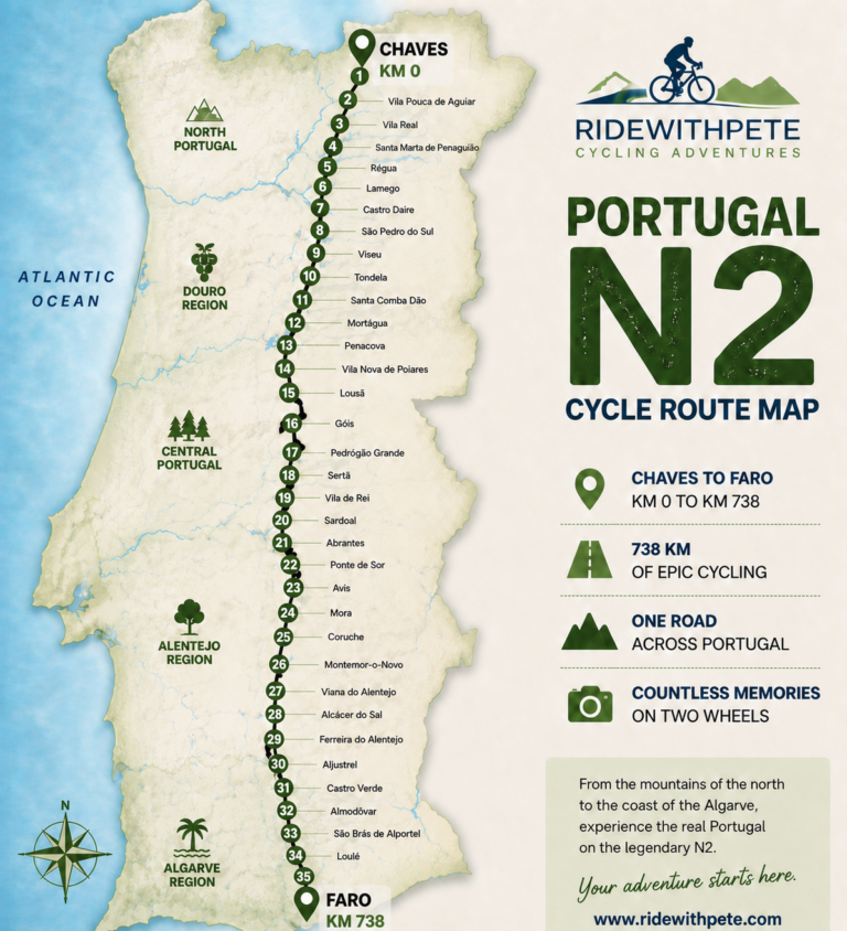
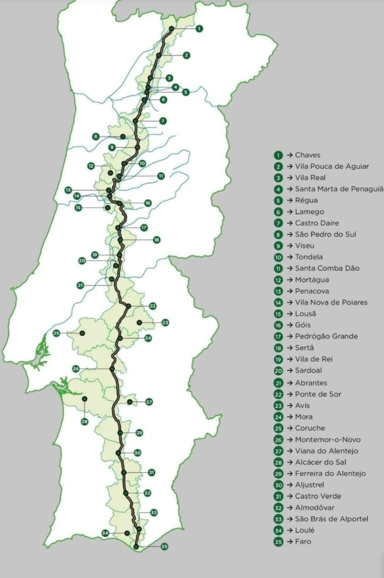
Stretching approximately 739 kilometres from Chaves in northern Portugal to Faro in the Algarve, the Portugal N2 cycle route offers something increasingly rare: the chance to cross an entire country by bicycle while following one historic road.
Known officially as the Estrada Nacional 2, or EN2, the route passes through mountain landscapes, vineyard country, river valleys, forests, traditional towns, the open plains of the Alentejo and, finally, the hills of the Algarve.
Cycling the N2 is a considerable undertaking. It requires fitness, preparation and careful planning, but it rewards riders with an unforgettable view of Portugal beyond the familiar coastal resorts and major cities.
This guide explains the route, distance, terrain, stages, navigation and different ways to organise your own N2 cycling adventure.
Where Does the Portugal N2 Cycle Route Begin and End?
The traditional N2 journey begins at the kilometre-zero marker in Chaves, close to Portugal’s northern border with Spain. From there, the road travels south through the centre of the country before reaching its final marker in Faro.
The complete journey is approximately 739 kilometres, although the exact distance recorded on your cycling computer may vary. Differences can result from accommodation locations, diversions, route choices and the way individual devices calculate distance.
Most cyclists ride from north to south:
Start: Chaves
Finish: Faro
Distance: Approximately 739 kilometres
Typical duration: Seven to twelve riding days
Road surface: Predominantly paved roads
Suitable bicycles: Road, endurance, touring or appropriate electric bicycle
Beginning in Chaves and finishing in Faro also gives the journey a satisfying sense of progression. The changing scenery, vegetation, architecture and climate make it feel as though you are travelling through several different versions of Portugal.
Why Is Portugal’s N2 So Popular With Cyclists?
The N2 is frequently described as Portugal’s answer to Route 66, but its appeal to cyclists goes beyond the comparison.
It provides a clear north-to-south challenge with a recognisable beginning and end. Rather than riding a circular route and returning to where you started, you make visible progress across the country every day.
The route passes through parts of Portugal that many international visitors never experience. Between the larger towns are small communities, roadside cafés, traditional restaurants, quiet landscapes and long sections where the country feels wonderfully unhurried.
There is also the personal achievement. Reaching Faro after starting nearly 739 kilometres away in Chaves creates a genuine end-to-end accomplishment.
However, the N2 should not be mistaken for an easy sightseeing holiday. The distance, climbing, weather and repeated days in the saddle make it a serious cycling challenge.
What Is the Terrain Like?
The character of the N2 changes considerably as it travels south.
Northern Portugal
The opening part of the route contains green hills, mountain roads and frequent changes in elevation. Climbs may not always look dramatic on a map, but their repeated nature can gradually wear down riders who start too quickly.
The north rewards controlled pacing. There is little benefit in attacking the early climbs when several hundred kilometres still lie ahead.
Central Portugal
Central Portugal brings wooded hills, river valleys, winding roads and further sustained climbing. Some sections flow beautifully, with climbs followed by rewarding descents, while others require patience and consistent effort.
This is often where the cumulative nature of the journey becomes noticeable. Riders are no longer completing a single long ride; they are waking up and doing it again, day after day.
The Alentejo
The landscape becomes more open as the route reaches the Alentejo. Cork oaks, farmland and wide horizons replace many of the enclosed northern valleys.
Although the terrain can look easier, long distances, exposed roads, wind and heat may create a different challenge. Services can also be more widely separated, making food and water planning particularly important.
The Algarve
The final approach to Faro is not simply a flat roll towards the coast. The N2 crosses the hills of the Algarve before descending towards its southern finish.
Tired legs must still deal with meaningful climbing, but the knowledge that Faro is approaching gives the final stage a special atmosphere.
How Difficult Is Cycling the N2?
The N2 is achievable for a well-prepared recreational cyclist, but it should be treated with respect.
You do not need to be a racer. You do need to be comfortable riding for several hours, climbing repeatedly and completing long distances on consecutive days.
Difficulty depends on several factors:
- The number of days you allow
- Your fitness and multi-day riding experience
- The weight of your bicycle and luggage
- Your gearing
- Weather and wind conditions
- How well you eat, drink and recover
- Whether you have luggage and vehicle support
- How aggressively you ride the early stages
Completing the route in seven days produces an average of more than 100 kilometres per day. A longer itinerary reduces the daily distance and creates more time for photographs, café stops and recovery.
Even with shorter stages, the total climbing and repeated days in the saddle remain significant. Preparation should therefore include consecutive-day rides rather than only one long weekend ride followed by several days of rest.
Cycling the N2 in Seven Stages
There is no single compulsory way to divide the N2. Your stages will depend on fitness, accommodation, available time and whether you are riding independently or with organised support.
A seven-day itinerary creates a demanding but practical end-to-end challenge. One example looks like this:
Day 1: Leaving Chaves
Approximately 93 km and 1,150 metres of climbing
The opening stage introduces the rolling mountain roads of northern Portugal. Excitement can make it easy to ride too hard, so the main objective should be finding a sustainable rhythm.
Day 2: Northern Climbs and Valley Views
Approximately 87 km and 1,540 metres of climbing
The shorter distance does not make this an easy day. Repeated climbing and descending make pacing, hydration and sensible gearing important.
Day 3: Into the Heart of Portugal
Approximately 95 km and 1,050 metres of climbing
Forested roads, river landscapes and flowing sections help the journey settle into a more familiar rhythm. By now, recovery between stages becomes as important as fitness.
Day 4: The Major Climbing Challenge
Approximately 115 km and 1,900 metres of climbing
This is a substantial stage combining distance with the greatest amount of climbing. Patience on the early ascents and consistent nutrition can make the difference later in the day.
Day 5: The Long Alentejo Stage
Approximately 144 km and 1,300 metres of climbing
The longest stage crosses increasingly open landscapes. A steady pace and carefully planned food and water stops are essential.
Day 6: Heading Towards the Algarve
Approximately 110 km and 930 metres of climbing
Rolling southern roads carry the journey closer to the Algarve. Fatigue has accumulated, but the finish is beginning to feel within reach.
Day 7: The Final Ride to Faro
Approximately 97 km and 1,100 metres of climbing
The route still demands effort before the final descent towards Faro. Arriving at the N2 marker completes the journey from one end of Portugal to the other.
These figures are approximate and should not replace a checked route file. Accommodation choices, diversions and road conditions can all change the final distance and climbing recorded.
Riders wanting a more relaxed journey can divide the N2 across additional days. This reduces the daily pressure, but requires more accommodation bookings and a larger overall travel budget.
Navigating the Portugal N2 Cycle Route
Although the journey follows the historic N2, navigation is not as simple as staying on one clearly marked road for 739 kilometres.
Changes to Portugal’s road network mean that parts of the historic route have been bypassed, reclassified or interrupted by newer roads. Signs may be inconsistent, and following the wrong modern road could take you towards unsuitable or prohibited sections.
A reliable GPX route is therefore strongly recommended.
Most cyclists use a Garmin, Wahoo, Hammerhead or a navigation application such as Komoot or Ride with GPS. Whatever device you choose, load and test the route before travelling.
Good navigation preparation includes:
- Downloading the complete route and individual daily stages
- Confirming that the files work correctly on your device
- Making maps available offline
- Carrying a charging cable and power bank
- Checking for road closures or diversions
- Keeping a backup route on your telephone
- Reviewing the following day’s route each evening
A GPX file is an important tool, but it does not remove personal responsibility. Roadworks, fires, severe weather, events and temporary closures can affect the route. Always obey official signs and assess the conditions in front of you.
Food, Water and Daily Planning
One pleasure of cycling the N2 is stopping at local cafés and restaurants, but you should not assume that food and water will always be available exactly when needed.
Opening hours in smaller communities can vary, and some businesses may close during quieter periods. Distances between reliable stops may also increase in more rural areas.
Start each day with sufficient water and emergency food. Refill when the opportunity arises rather than waiting until every bottle is empty.
On hotter days, an early start can reduce exposure to the strongest afternoon temperatures. Heat management is especially important in open sections where shade may be limited.
Your daily planning should account for:
- Distance and expected climbing
- Weather and wind
- Food and water stops
- Accommodation check-in arrangements
- Bicycle storage
- Device battery life
- Emergency alternatives
- Recovery time after the ride
What Bicycle and Equipment Do You Need?
A well-maintained road, endurance or touring bicycle is suitable for most riders. A suitable electric bicycle can also be used, provided its battery has enough capacity for the daily distance and climbing.
Comfort and reliability matter more than having the lightest bicycle.
Before travelling, check:
- Brakes and brake pads
- Tyres and tyre condition
- Gearing suitable for repeated climbing
- Chain, cassette and drivetrain
- Saddle comfort
- Bicycle fit
- Lights and charging equipment
- Spare inner tubes or tubeless repair equipment
- Pump or inflation device
- Basic tools and spare parts
Do not begin a multi-day ride with untested equipment. New shoes, saddles, clothing or major position changes should be tested well before the journey.
Self-Supported, Self-Guided or Fully Guided?
There are several ways to experience the N2. The right choice depends on your confidence, budget and how much responsibility you want to carry.
Independent and Self-Supported
A completely independent rider plans the route, books accommodation, carries luggage and deals personally with navigation, food, mechanical problems and unexpected changes.
This offers maximum freedom and can reduce costs, but it requires the most preparation and self-reliance.
Prepared Self-Guided Ride
A prepared self-guided option suits cyclists who want to choose their own dates and travelling companions but do not want to build the journey from a blank page.
The Ride With Pete N2 Self-Guided Adventure Pack provides prepared GPX routes, daily stage information and practical planning guidance. You remain responsible for accommodation, luggage, meals, transport and decisions during the ride.
Fully Guided and Supported Tour
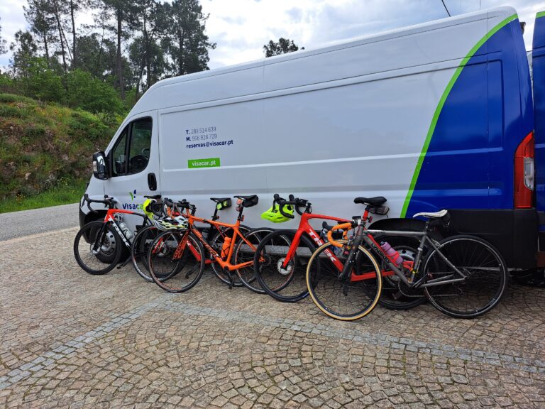
A guided tour removes much of the logistical burden. Accommodation, luggage transfers, planned stops and daily support are organised, allowing riders to concentrate on cycling.
On the Ride With Pete Guided N2 Cycling Tour, Pete rides every stage with the group while an experienced support driver handles luggage and planned meeting points.
This is the most supported option and is particularly valuable for cyclists who want the reassurance of local knowledge, a small group and practical assistance throughout the week.
Plan Your N2 Ride
Use these detailed guides to decide whether the N2 suits you and begin planning the journey:
- How Hard Is It to Cycle Portugal’s N2? — Understand the required fitness, daily distances, climbing and training.
- Cycling Portugal’s N2 in 7 Days — Explore the distance, climbing, character and difficulty of every stage.
- The Best Time of Year to Cycle Portugal’s N2 — Compare seasonal heat, rain and daylight before choosing your dates.
- Guided or Self-Guided N2 Cycling — Decide how much freedom, planning and practical support you want.
- Portugal Cycling Holidays: Why the N2 Should Be on Your List — See how the N2 compares with other ways to experience Portugal by bicycle.
Is the Portugal N2 Cycle Route Right for You?
The N2 could be right for you if the idea of crossing Portugal by bicycle feels exciting rather than simply intimidating.
You should be willing to prepare properly, ride consistently and accept that some days will be difficult. You should also be able to manage your own bicycle, respond sensibly to changing conditions and keep going when tiredness begins to accumulate.
In return, you experience Portugal changing around you one day at a time—from the northern hills and river valleys to the Alentejo and the final approach to Faro.
Whether you ride independently, use a prepared self-guided package or join a fully supported tour, the N2 is more than a line on a map. It is a journey across Portugal and an achievement you are unlikely to forget.